Objektsuche
Hier finden Sie alle Kunst- und Kulturobjekte unserer digitalen Schatzkammer: Hochauflösend digitalisiert ermöglichen sie das Hineinzoomen bis in kleinste Details und lassen so Geschichte und Kultur lebendig werden. Mit verschiedensten Filtermöglichkeiten können Sie zudem Ihre eigenen Suchergebnisse ganz nach Ihren Wünschen sortieren oder spezifizieren.
Filter
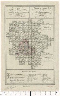
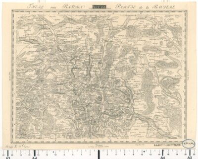
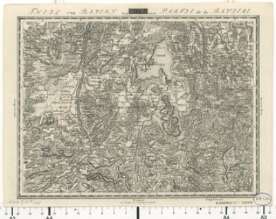
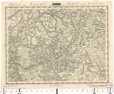
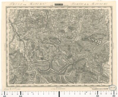
Topographisch-militairische Charte von Teutschland (Bayern) - Gesamtkarte
- Bayerische Staatsbibliothek
- Signatur: Mapp. XI,51 d
- Identifikator: BV017643769
- 1800 - 1815
- Weimar
- CC BY-NC-SA 4.0
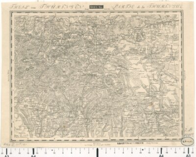
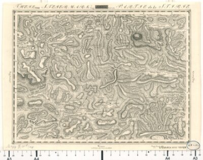
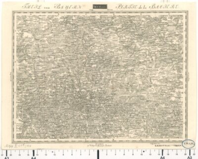
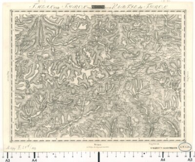
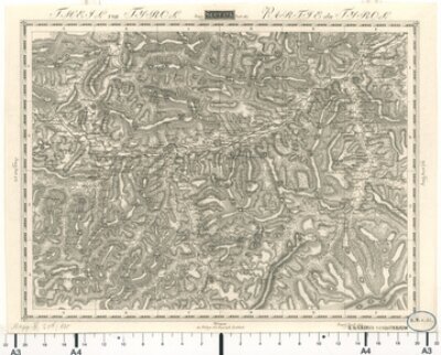
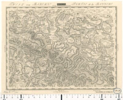
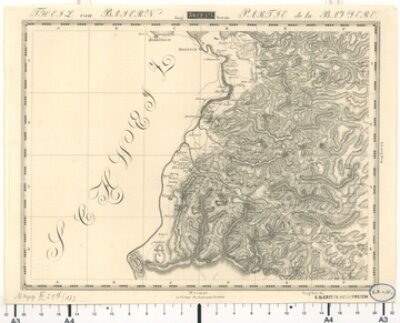
Topographisch-militairische Charte von Teutschland, Blatt 95: Theil von Thüringen
- Bayerische Staatsbibliothek
- Identifikator: BV000451009
- Signatur: Mapp. XI,51 d-95
- 1800 - 1815
- Weimar
- CC BY-NC-SA 4.0
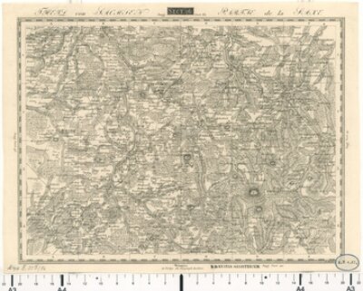
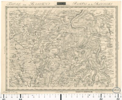
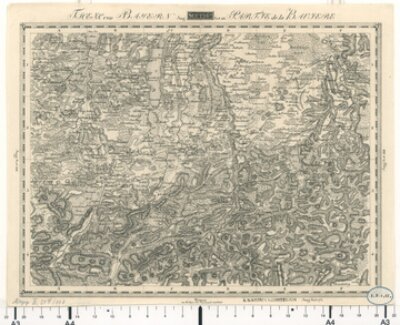
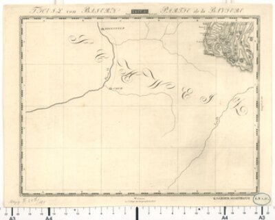
Topographisch-militairische Charte von Teutschland, Blatt 96: Theil von Sachsen
- Bayerische Staatsbibliothek
- Identifikator: BV000451010
- Signatur: Mapp. XI,51 d-96
- 1800 - 1815
- Weimar
- CC BY-NC-SA 4.0
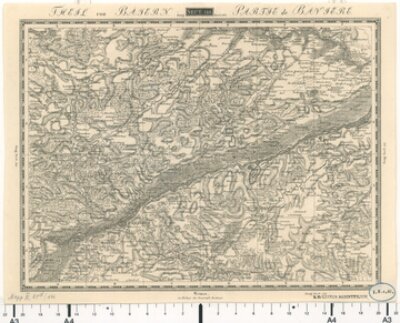
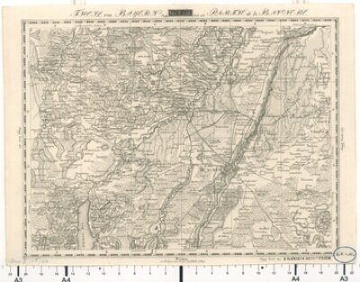
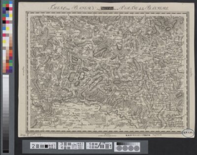
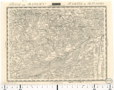
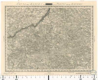
Topographisch-militairische Charte von Teutschland, Blatt 133: Theil von Baiern
- Bayerische Staatsbibliothek
- Signatur: Mapp. XI,51 d-133
- Identifikator: BV000451018
- 1800 - 1815
- Weimar
- CC BY-NC-SA 4.0
Topographisch-militairische Charte von Teutschland, Blatt 178: Theil von Steiermark
- Bayerische Staatsbibliothek
- Signatur: Mapp. XI,51 d-178
- Identifikator: BV000451041
- 1800 - 1815
- Weimar
- CC BY-NC-SA 4.0
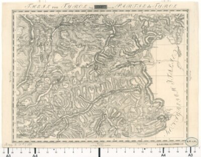
Topographisch-militairische Charte von Teutschland, Blatt 183: Theil von Tyrol
- Bayerische Staatsbibliothek
- Identifikator: BV000451044
- Signatur: Mapp. XI,51 d-183
- 1800 - 1815
- Weimar
- CC BY-NC-SA 4.0
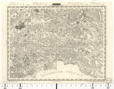
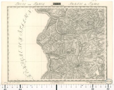
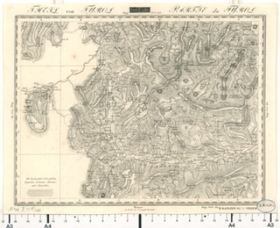
Topographisch-militairische Charte von Teutschland, Blatt 184: Theil von Tyrol
- Bayerische Staatsbibliothek
- Signatur: Mapp. XI,51 d-184
- Identifikator: BV000451045
- 1800 - 1815
- Weimar
- CC BY-NC-SA 4.0
Topographisch-militairische Charte von Teutschland, Blatt 190: Theil von Tyrol
- Bayerische Staatsbibliothek
- Identifikator: BV000451048
- Signatur: Mapp. XI,51 d-190
- 1800 - 1815
- Weimar
- CC BY-NC-SA 4.0
Topographisch-militairische Charte von Teutschland, Blatt 189: Theil von Tyrol
- Bayerische Staatsbibliothek
- Identifikator: BV000451047
- Signatur: Mapp. XI,51 d-189
- 1800 - 1815
- Weimar
- CC BY-NC-SA 4.0
Topographisch-militairische Charte von Teutschland, Blatt 132: Theil von Bayern
- Bayerische Staatsbibliothek
- Signatur: Mapp. XI,51 d-132
- Identifikator: BV000451017
- 1800 - 1815
- Weimar
- CC BY-NC-SA 4.0
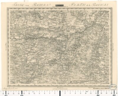
Topographisch-militairische Charte von Teutschland, Blatt 146: Theil von Bayern
- Bayerische Staatsbibliothek
- Identifikator: BV000451023
- Signatur: Mapp. XI,51 d-146
- 1800 - 1815
- Weimar
- CC BY-NC-SA 4.0
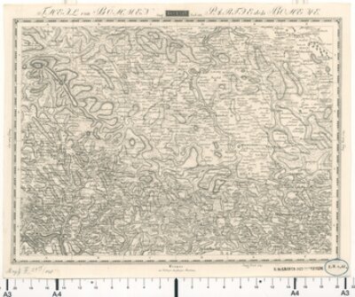
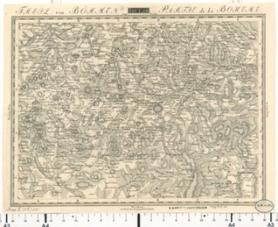
Topographisch-militairische Charte von Teutschland, Blatt 148: Theil von Böhmen
- Bayerische Staatsbibliothek
- Signatur: Mapp. XI,51 d-148
- Identifikator: BV000451025
- 1800 - 1815
- Weimar
- CC BY-NC-SA 4.0
Topographisch-militairische Charte von Teutschland, Blatt 155: Theil von Bayern
- Bayerische Staatsbibliothek
- Signatur: Mapp. XI,51 d-156
- Identifikator: BV000451027
- 1800 - 1815
- Weimar
- CC BY-NC-SA 4.0
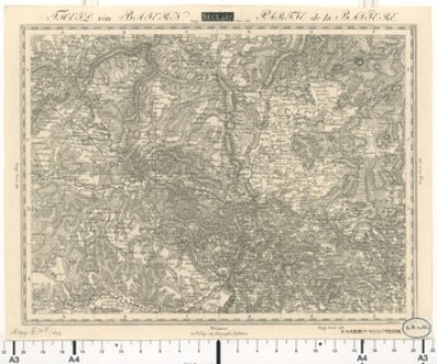
Topographisch-militairische Charte von Teutschland, Blatt 157: Theil von Bayern
- Bayerische Staatsbibliothek
- Identifikator: BV000451028
- Signatur: Mapp. XI,51 d-157
- 1800 - 1815
- Weimar
- CC BY-NC-SA 4.0
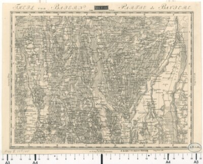
Topographisch-militairische Charte von Teutschland, Blatt 166: Theil von Baiern
- Bayerische Staatsbibliothek
- Identifikator: BV000451032
- Signatur: Mapp. XI,51 d-166
- 1800 - 1815
- Weimar
- CC BY-NC-SA 4.0
Topographisch-militairische Charte von Teutschland, Blatt 168: Theil von Bayern
- Bayerische Staatsbibliothek
- Identifikator: BV000451034
- Signatur: Mapp. XI,51 d-168
- 1800 - 1815
- Weimar
- CC BY-NC-SA 4.0
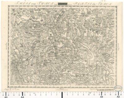
Topographisch-militairische Charte von Teutschland, Blatt 174: Theil von Tyrol
- Bayerische Staatsbibliothek
- Identifikator: BV000451037
- Signatur: Mapp. XI,51 d-174
- 1800 - 1815
- Weimar
- CC BY-NC-SA 4.0
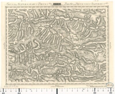
Topographisch-militairische Charte von Teutschland, Blatt 175: Theil von Tyrol
- Bayerische Staatsbibliothek
- Signatur: Mapp. XI,51 d-175
- Identifikator: BV000451038
- 1800 - 1815
- Weimar
- CC BY-NC-SA 4.0
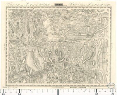
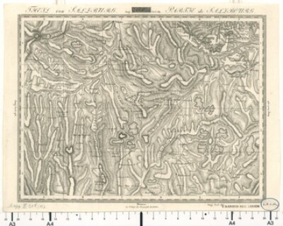
Topographisch-militairische Charte von Teutschland, Blatt 176: Theil von Salzburg
- Bayerische Staatsbibliothek
- Signatur: Mapp. XI,51 d-176
- Identifikator: BV000451039
- 1800 - 1815
- Weimar
- CC BY-NC-SA 4.0
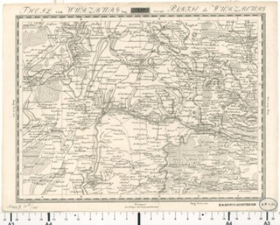
Topographisch-militairische Charte von Teutschland, Blatt 108: Theil von Würzburg
- Bayerische Staatsbibliothek
- Identifikator: BV000451011
- Signatur: Mapp. XI,51 d-108
- 1800 - 1815
- Weimar
- CC BY-NC-SA 4.0
Topographisch-militairische Charte von Teutschland, Blatt 110: Theil von Böhmen
- Bayerische Staatsbibliothek
- Signatur: Mapp. XI,51 d-110
- Identifikator: BV000451013
- 1800 - 1815
- Weimar
- CC BY-NC-SA 4.0
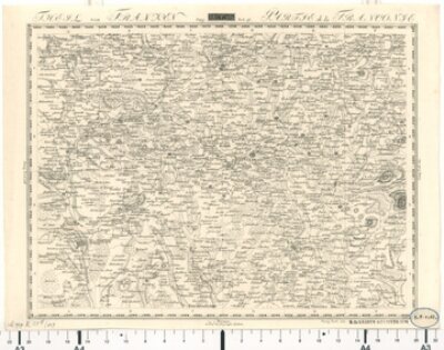
Topographisch-militairische Charte von Teutschland, Blatt 109: Theil von Franken
- Bayerische Staatsbibliothek
- Signatur: Mapp. XI,51 d-109
- Identifikator: BV000451012
- 1800 - 1815
- Weimar
- CC BY-NC-SA 4.0
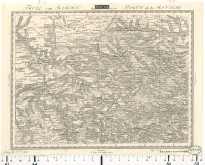
Topographisch-militairische Charte von Teutschland, Blatt 120: Theil von Bayern
- Bayerische Staatsbibliothek
- Identifikator: BV000451014
- Signatur: Mapp. XI,51 d-120
- 1800 - 1815
- Weimar
- CC BY-NC-SA 4.0
Topographisch-militairische Charte von Teutschland, Blatt 121: Theil von Baiern
- Bayerische Staatsbibliothek
- Signatur: Mapp. XI,51 d-121
- Identifikator: BV000451015
- 1800 - 1815
- Weimar
- CC BY-NC-SA 4.0
Topographisch-militairische Charte von Teutschland, Blatt 135: Theil von Bayern
- Bayerische Staatsbibliothek
- Identifikator: BV000451020
- Signatur: Mapp. XI,51 d-135
- 1800 - 1815
- Weimar
- CC BY-NC-SA 4.0
Topographisch-militairische Charte von Teutschland, Blatt 122: Theil von Baiern
- Bayerische Staatsbibliothek
- Signatur: Mapp. XI,51 d-122
- Identifikator: BV000451016
- 1800 - 1815
- Weimar
- CC BY-NC-SA 4.0
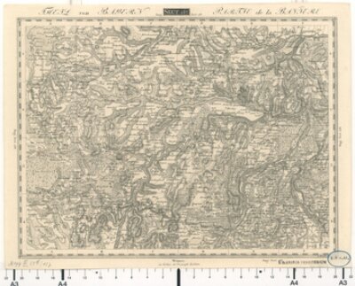
Topographisch-militairische Charte von Teutschland, Blatt 134: Theil von Bayern
- Bayerische Staatsbibliothek
- Identifikator: BV000451019
- Signatur: Mapp. XI,51 d-134
- 1800 - 1815
- Weimar
- CC BY-NC-SA 4.0
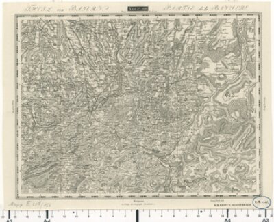
Topographisch-militairische Charte von Teutschland, Blatt 144: Theil von Bayern
- Bayerische Staatsbibliothek
- Identifikator: BV000451021
- Signatur: Mapp. XI,51 d-144
- 1800 - 1815
- Weimar
- CC BY-NC-SA 4.0
Topographisch-militairische Charte von Teutschland, Blatt 145: Theil von Baiern
- Bayerische Staatsbibliothek
- Identifikator: BV000451022
- Signatur: Mapp. XI,51 d-145
- 1800 - 1815
- Weimar
- CC BY-NC-SA 4.0
Topographisch-militairische Charte von Teutschland, Blatt 147: Theil von Baiern
- Bayerische Staatsbibliothek
- Signatur: Mapp. XI,51 d-147
- Identifikator: BV000451024
- 1800 - 1815
- Weimar
- CC BY-NC-SA 4.0
Topographisch-militairische Charte von Teutschland, Blatt 155: Theil von Baiern
- Bayerische Staatsbibliothek
- Identifikator: BV000451026
- Signatur: Mapp. XI,51 d-155
- 1800 - 1815
- Weimar
- CC BY-NC-SA 4.0
Topographisch-militairische Charte von Teutschland, Blatt 158: Theil von Bayern
- Bayerische Staatsbibliothek
- Signatur: Mapp. XI,51 d-158
- Identifikator: BV000451029
- 1800 - 1815
- Weimar
- CC BY-NC-SA 4.0
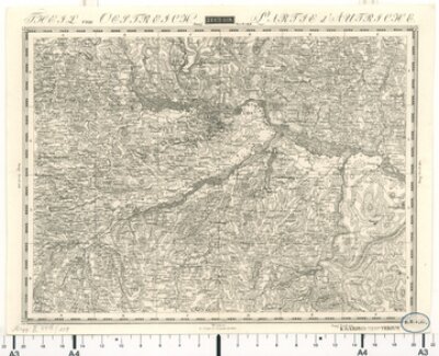
Topographisch-militairische Charte von Teutschland, Blatt 159: Theil von Oestreich
- Bayerische Staatsbibliothek
- Signatur: Mapp. XI,51 d-159
- Identifikator: BV000451030
- 1800 - 1815
- Weimar
- CC BY-NC-SA 4.0
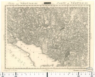
Topographisch-militairische Charte von Teutschland, Blatt 165: Theil von Würtemberg
- Bayerische Staatsbibliothek
- Signatur: Mapp. XI,51 d-165
- Identifikator: BV000451031
- 1800 - 1815
- Weimar
- CC BY-NC-SA 4.0
Topographisch-militairische Charte von Teutschland, Blatt 167: Theil von Bayern
- Bayerische Staatsbibliothek
- Identifikator: BV000451033
- Signatur: Mapp. XI,51 d-167
- 1800 - 1815
- Weimar
- CC BY-NC-SA 4.0
Topographisch-militairische Charte von Teutschland, Blatt 169: Theil von Bayern
- Bayerische Staatsbibliothek
- Signatur: Mapp. XI,51 d-169
- Identifikator: BV000451035
- 1800 - 1815
- Weimar
- CC BY-NC-SA 4.0
Topographisch-militairische Charte von Teutschland, Blatt 173: Theil von Baiern
- Bayerische Staatsbibliothek
- Signatur: Mapp. XI,51 d-173
- Identifikator: BV000451036
- 1800 - 1815
- Weimar
- CC BY-NC-SA 4.0
Topographisch-militairische Charte von Teutschland, Blatt 181: Theil von Baiern
- Bayerische Staatsbibliothek
- Identifikator: BV000451042
- Signatur: Mapp. XI,51 d-181
- 1800 - 1815
- Weimar
- CC BY-NC-SA 4.0
Topographisch-militairische Charte von Teutschland, Blatt 177: Theil von Salzburg
- Bayerische Staatsbibliothek
- Identifikator: BV000451040
- Signatur: Mapp. XI,51 d-177
- 1800 - 1815
- Weimar
- CC BY-NC-SA 4.0
Topographisch-militairische Charte von Teutschland, Blatt 182: Theil von Tyrol
- Bayerische Staatsbibliothek
- Identifikator: BV000451043
- Signatur: Mapp. XI,51 d-182
- 1800 - 1815
- Weimar
- CC BY-NC-SA 4.0
Topographisch-militairische Charte von Teutschland, Blatt 185: Theil der Illyrischen Provinzen
- Bayerische Staatsbibliothek
- Identifikator: BV000451046
- Signatur: Mapp. XI,51 d-185
- 1800 - 1815
- Weimar
- CC BY-NC-SA 4.0
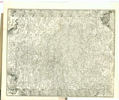
Finckh: Sacri Romani Imperii Circuli Et Electoratus Bavariae ; Gesamtkarte
- Bayerische Staatsbibliothek
- Identifikator: BV000451000
- Signatur: Mapp. XI,27 f-1
- 1684
- Freising
- CC BY-NC-SA 4.0
Finckh: S. Rom. Imperii Circuli Et Electoratus Bavariae … ; Gesamtkarte
- Bayerische Staatsbibliothek
- Identifikator: BV000451002
- Signatur: Mapp. XI,27 e
- 1684
- Augsburg
- CC BY-NC-SA 4.0
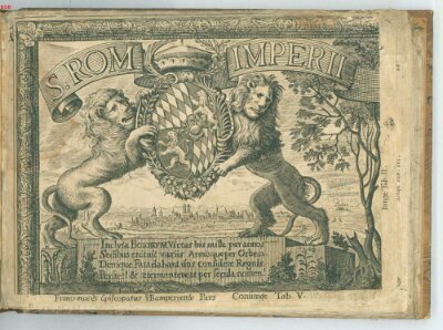
Finckh: Sacri Romani Imperii Circuli Et Electoratus Bavariae ; Bl. 14
- Bayerische Staatsbibliothek
- Identifikator: BV000451000
- Signatur: Mapp. XI,27 f-1
- 1684
- Freising
- CC BY-NC-SA 4.0
Finckh: Sacri Romani Imperii Circuli Et Electoratus Bavariae ; Bl. 11
- Bayerische Staatsbibliothek
- Identifikator: BV000451000
- Signatur: Mapp. XI,27 f-1
- 1684
- Freising
- CC BY-NC-SA 4.0
Finckh: Sacri Romani Imperii Circuli Et Electoratus Bavariae ; Bl. 15
- Bayerische Staatsbibliothek
- Identifikator: BV000451000
- Signatur: Mapp. XI,27 f-1
- 1684
- Freising
- CC BY-NC-SA 4.0
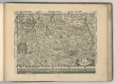
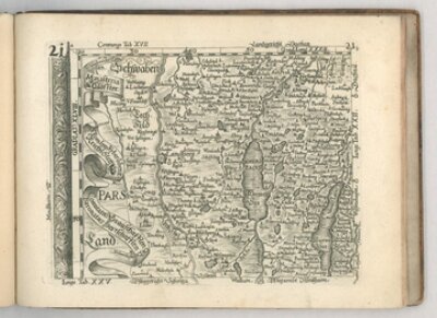
Finckh: Sacri Romani Imperii Circuli Et Electoratus Bavariae ; Bl. 19
- Bayerische Staatsbibliothek
- Identifikator: BV000451000
- Signatur: Mapp. XI,27 f-1
- 1684
- Freising
- CC BY-NC-SA 4.0
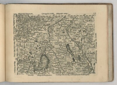
Finckh: Sacri Romani Imperii Circuli Et Electoratus Bavariae ; Bl. 21
- Bayerische Staatsbibliothek
- Identifikator: BV000451000
- Signatur: Mapp. XI,27 f-1
- 1684
- Freising
- CC BY-NC-SA 4.0
Finckh: Sacri Romani Imperii Circuli Et Electoratus Bavariae ; Bl. 23
- Bayerische Staatsbibliothek
- Identifikator: BV000451000
- Signatur: Mapp. XI,27 f-1
- 1684
- Freising
- CC BY-NC-SA 4.0
Finckh: Sacri Romani Imperii Circuli Et Electoratus Bavariae ; Bl. 26
- Bayerische Staatsbibliothek
- Identifikator: BV000451000
- Signatur: Mapp. XI,27 f-1
- 1684
- Freising
- CC BY-NC-SA 4.0