Allgemeine Suche

Hier finden Sie alles, was bavarikon zu bieten hat. Durchsuchen Sie unsere digitale Schatzkammer ganz nach Ihren Wünschen und entdecken Sie unsere gesamten Schätze.

Neben den volldigitalisierten Kunst- und Kulturobjekten finden Sie hier auch Personen, Orte, Karten, Ausstellungen, Sammlungen, Partner oder Datensätze.

Durchsuchen Sie Beschreibungen und Metadaten mit unserer Volltextsuche oder filtern Sie Ihre Suchergebnisse nach Belieben.

Filter
Der Schwaebische Kreis nebst den ősterreichischen Besitzungen in Schwaben
  • Bayerische Staatsbibliothek
  • Identifikator: BV003594019
  • Signatur: Mapp. XII,168 a
  • Anton Friedrich Büsching
  • Franz L. Güssefeld
  • 1796
  • Weimar
  • CC BY-NC-SA 4.0
Güssefeld: Charte den Bayerischen Kreis vorstellend
  • Bayerische Staatsbibliothek
  • Identifikator: BV000451351
  • Signatur: Mapp. XI,40
  • Anton Friedrich Büsching
  • Franz L. Güssefeld
  • 1796
  • Weimar
  • CC BY-NC-SA 4.0
Charte von dem Nordwestlichen Theile des Königreichs Bayern, dem Grossherzogthume Würzburg, dem Fürstenthume Aschaffenburg &c.c. oder Der Maÿn
  • Bayerische Staatsbibliothek
  • Identifikator: BV000544752
  • Signatur: Mapp. XI,96 yf
  • 1807
  • Weimar
  • CC BY-NC-SA 4.0
Topographisch-militairische Charte von Teutschland, Blatt 96: Theil von Sachsen
  • Bayerische Staatsbibliothek
  • Identifikator: BV000451010
  • Signatur: Mapp. XI,51 d-96
  • 1800 - 1815
  • Weimar
  • CC BY-NC-SA 4.0
Topographisch-militairische Charte von Teutschland, Blatt 120: Theil von Bayern
  • Bayerische Staatsbibliothek
  • Identifikator: BV000451014
  • Signatur: Mapp. XI,51 d-120
  • 1800 - 1815
  • Weimar
  • CC BY-NC-SA 4.0
Topographisch-militairische Charte von Teutschland, Blatt 145: Theil von Baiern
  • Bayerische Staatsbibliothek
  • Identifikator: BV000451022
  • Signatur: Mapp. XI,51 d-145
  • 1800 - 1815
  • Weimar
  • CC BY-NC-SA 4.0
Topographisch-militairische Charte von Teutschland, Blatt 155: Theil von Bayern
  • Bayerische Staatsbibliothek
  • Signatur: Mapp. XI,51 d-156
  • Identifikator: BV000451027
  • 1800 - 1815
  • Weimar
  • CC BY-NC-SA 4.0
Topographisch-militairische Charte von Teutschland, Blatt 157: Theil von Bayern
  • Bayerische Staatsbibliothek
  • Identifikator: BV000451028
  • Signatur: Mapp. XI,51 d-157
  • 1800 - 1815
  • Weimar
  • CC BY-NC-SA 4.0
Topographisch-militairische Charte von Teutschland, Blatt 159: Theil von Oestreich
  • Bayerische Staatsbibliothek
  • Signatur: Mapp. XI,51 d-159
  • Identifikator: BV000451030
  • 1800 - 1815
  • Weimar
  • CC BY-NC-SA 4.0
Topographisch-militairische Charte von Teutschland, Blatt 167: Theil von Bayern
  • Bayerische Staatsbibliothek
  • Identifikator: BV000451033
  • Signatur: Mapp. XI,51 d-167
  • 1800 - 1815
  • Weimar
  • CC BY-NC-SA 4.0
Topographisch-militairische Charte von Teutschland, Blatt 175: Theil von Tyrol
  • Bayerische Staatsbibliothek
  • Signatur: Mapp. XI,51 d-175
  • Identifikator: BV000451038
  • 1800 - 1815
  • Weimar
  • CC BY-NC-SA 4.0
Topographisch-militairische Charte von Teutschland, Blatt 184: Theil von Tyrol
  • Bayerische Staatsbibliothek
  • Signatur: Mapp. XI,51 d-184
  • Identifikator: BV000451045
  • 1800 - 1815
  • Weimar
  • CC BY-NC-SA 4.0
Topographisch-militairische Charte von Teutschland, Blatt 109: Theil von Franken
  • Bayerische Staatsbibliothek
  • Signatur: Mapp. XI,51 d-109
  • Identifikator: BV000451012
  • 1800 - 1815
  • Weimar
  • CC BY-NC-SA 4.0
Topographisch-militairische Charte von Teutschland, Blatt 132: Theil von Bayern
  • Bayerische Staatsbibliothek
  • Signatur: Mapp. XI,51 d-132
  • Identifikator: BV000451017
  • 1800 - 1815
  • Weimar
  • CC BY-NC-SA 4.0
Topographisch-militairische Charte von Teutschland, Blatt 133: Theil von Baiern
  • Bayerische Staatsbibliothek
  • Signatur: Mapp. XI,51 d-133
  • Identifikator: BV000451018
  • 1800 - 1815
  • Weimar
  • CC BY-NC-SA 4.0
Topographisch-militairische Charte von Teutschland, Blatt 135: Theil von Bayern
  • Bayerische Staatsbibliothek
  • Identifikator: BV000451020
  • Signatur: Mapp. XI,51 d-135
  • 1800 - 1815
  • Weimar
  • CC BY-NC-SA 4.0
Topographisch-militairische Charte von Teutschland, Blatt 146: Theil von Bayern
  • Bayerische Staatsbibliothek
  • Identifikator: BV000451023
  • Signatur: Mapp. XI,51 d-146
  • 1800 - 1815
  • Weimar
  • CC BY-NC-SA 4.0
Topographisch-militairische Charte von Teutschland, Blatt 148: Theil von Böhmen
  • Bayerische Staatsbibliothek
  • Signatur: Mapp. XI,51 d-148
  • Identifikator: BV000451025
  • 1800 - 1815
  • Weimar
  • CC BY-NC-SA 4.0
Topographisch-militairische Charte von Teutschland, Blatt 165: Theil von Würtemberg
  • Bayerische Staatsbibliothek
  • Signatur: Mapp. XI,51 d-165
  • Identifikator: BV000451031
  • 1800 - 1815
  • Weimar
  • CC BY-NC-SA 4.0
Topographisch-militairische Charte von Teutschland, Blatt 166: Theil von Baiern
  • Bayerische Staatsbibliothek
  • Identifikator: BV000451032
  • Signatur: Mapp. XI,51 d-166
  • 1800 - 1815
  • Weimar
  • CC BY-NC-SA 4.0
Topographisch-militairische Charte von Teutschland, Blatt 168: Theil von Bayern
  • Bayerische Staatsbibliothek
  • Identifikator: BV000451034
  • Signatur: Mapp. XI,51 d-168
  • 1800 - 1815
  • Weimar
  • CC BY-NC-SA 4.0
Topographisch-militairische Charte von Teutschland, Blatt 169: Theil von Bayern
  • Bayerische Staatsbibliothek
  • Signatur: Mapp. XI,51 d-169
  • Identifikator: BV000451035
  • 1800 - 1815
  • Weimar
  • CC BY-NC-SA 4.0
Topographisch-militairische Charte von Teutschland, Blatt 173: Theil von Baiern
  • Bayerische Staatsbibliothek
  • Signatur: Mapp. XI,51 d-173
  • Identifikator: BV000451036
  • 1800 - 1815
  • Weimar
  • CC BY-NC-SA 4.0
Topographisch-militairische Charte von Teutschland, Blatt 176: Theil von Salzburg
  • Bayerische Staatsbibliothek
  • Signatur: Mapp. XI,51 d-176
  • Identifikator: BV000451039
  • 1800 - 1815
  • Weimar
  • CC BY-NC-SA 4.0
Topographisch-militairische Charte von Teutschland, Blatt 181: Theil von Baiern
  • Bayerische Staatsbibliothek
  • Identifikator: BV000451042
  • Signatur: Mapp. XI,51 d-181
  • 1800 - 1815
  • Weimar
  • CC BY-NC-SA 4.0
Topographisch-militairische Charte von Teutschland, Blatt 183: Theil von Tyrol
  • Bayerische Staatsbibliothek
  • Identifikator: BV000451044
  • Signatur: Mapp. XI,51 d-183
  • 1800 - 1815
  • Weimar
  • CC BY-NC-SA 4.0
Topographisch-militairische Charte von Teutschland, Blatt 189: Theil von Tyrol
  • Bayerische Staatsbibliothek
  • Identifikator: BV000451047
  • Signatur: Mapp. XI,51 d-189
  • 1800 - 1815
  • Weimar
  • CC BY-NC-SA 4.0
Topographisch-militairische Charte von Teutschland, Blatt 190: Theil von Tyrol
  • Bayerische Staatsbibliothek
  • Identifikator: BV000451048
  • Signatur: Mapp. XI,51 d-190
  • 1800 - 1815
  • Weimar
  • CC BY-NC-SA 4.0
Topographisch-militairische Charte von Teutschland, Blatt 185: Theil der Illyrischen Provinzen
  • Bayerische Staatsbibliothek
  • Identifikator: BV000451046
  • Signatur: Mapp. XI,51 d-185
  • 1800 - 1815
  • Weimar
  • CC BY-NC-SA 4.0
Topographisch-militairische Charte von Teutschland (Bayern) - Gesamtkarte
  • Bayerische Staatsbibliothek
  • Signatur: Mapp. XI,51 d
  • Identifikator: BV017643769
  • 1800 - 1815
  • Weimar
  • CC BY-NC-SA 4.0
Topographisch-militairische Charte von Teutschland, Blatt 95: Theil von Thüringen
  • Bayerische Staatsbibliothek
  • Identifikator: BV000451009
  • Signatur: Mapp. XI,51 d-95
  • 1800 - 1815
  • Weimar
  • CC BY-NC-SA 4.0
Topographisch-militairische Charte von Teutschland, Blatt 108: Theil von Würzburg
  • Bayerische Staatsbibliothek
  • Identifikator: BV000451011
  • Signatur: Mapp. XI,51 d-108
  • 1800 - 1815
  • Weimar
  • CC BY-NC-SA 4.0
Topographisch-militairische Charte von Teutschland, Blatt 110: Theil von Böhmen
  • Bayerische Staatsbibliothek
  • Signatur: Mapp. XI,51 d-110
  • Identifikator: BV000451013
  • 1800 - 1815
  • Weimar
  • CC BY-NC-SA 4.0
Topographisch-militairische Charte von Teutschland, Blatt 121: Theil von Baiern
  • Bayerische Staatsbibliothek
  • Signatur: Mapp. XI,51 d-121
  • Identifikator: BV000451015
  • 1800 - 1815
  • Weimar
  • CC BY-NC-SA 4.0
Topographisch-militairische Charte von Teutschland, Blatt 122: Theil von Baiern
  • Bayerische Staatsbibliothek
  • Signatur: Mapp. XI,51 d-122
  • Identifikator: BV000451016
  • 1800 - 1815
  • Weimar
  • CC BY-NC-SA 4.0
Topographisch-militairische Charte von Teutschland, Blatt 134: Theil von Bayern
  • Bayerische Staatsbibliothek
  • Identifikator: BV000451019
  • Signatur: Mapp. XI,51 d-134
  • 1800 - 1815
  • Weimar
  • CC BY-NC-SA 4.0
Topographisch-militairische Charte von Teutschland, Blatt 144: Theil von Bayern
  • Bayerische Staatsbibliothek
  • Identifikator: BV000451021
  • Signatur: Mapp. XI,51 d-144
  • 1800 - 1815
  • Weimar
  • CC BY-NC-SA 4.0
Topographisch-militairische Charte von Teutschland, Blatt 147: Theil von Baiern
  • Bayerische Staatsbibliothek
  • Signatur: Mapp. XI,51 d-147
  • Identifikator: BV000451024
  • 1800 - 1815
  • Weimar
  • CC BY-NC-SA 4.0
Topographisch-militairische Charte von Teutschland, Blatt 155: Theil von Baiern
  • Bayerische Staatsbibliothek
  • Identifikator: BV000451026
  • Signatur: Mapp. XI,51 d-155
  • 1800 - 1815
  • Weimar
  • CC BY-NC-SA 4.0
Topographisch-militairische Charte von Teutschland, Blatt 158: Theil von Bayern
  • Bayerische Staatsbibliothek
  • Signatur: Mapp. XI,51 d-158
  • Identifikator: BV000451029
  • 1800 - 1815
  • Weimar
  • CC BY-NC-SA 4.0
Topographisch-militairische Charte von Teutschland, Blatt 174: Theil von Tyrol
  • Bayerische Staatsbibliothek
  • Identifikator: BV000451037
  • Signatur: Mapp. XI,51 d-174
  • 1800 - 1815
  • Weimar
  • CC BY-NC-SA 4.0
Topographisch-militairische Charte von Teutschland, Blatt 177: Theil von Salzburg
  • Bayerische Staatsbibliothek
  • Identifikator: BV000451040
  • Signatur: Mapp. XI,51 d-177
  • 1800 - 1815
  • Weimar
  • CC BY-NC-SA 4.0
Topographisch-militairische Charte von Teutschland, Blatt 178: Theil von Steiermark
  • Bayerische Staatsbibliothek
  • Signatur: Mapp. XI,51 d-178
  • Identifikator: BV000451041
  • 1800 - 1815
  • Weimar
  • CC BY-NC-SA 4.0
Topographisch-militairische Charte von Teutschland, Blatt 182: Theil von Tyrol
  • Bayerische Staatsbibliothek
  • Identifikator: BV000451043
  • Signatur: Mapp. XI,51 d-182
  • 1800 - 1815
  • Weimar
  • CC BY-NC-SA 4.0
Das Königreich Bayern
  • Bayerische Staatsbibliothek
  • Identifikator: BV000871938
  • Identifikator: urn:nbn:de:bvb:12-bsb00010873-3
  • Signatur: Mapp. XI,57 sb
  • Weiland, Karl Ferdinand
  • Geograph. Inst. [Verlag]
  • s.a. [nach 1866]
  • Weimar
  • CC BY-NC-SA 4.0
Coburg 1819
  • Plan der Residenz-Stadt Coburg
  • Bayerische Staatsbibliothek
  • Identifikator: BV013997845
  • Identifikator: urn:nbn:de:bvb:12-bsb00105699-1
  • Signatur: Geo.u. 208-20#S.308,Taf.5
  • Im Verlage des Geogr. Instituts [Verlag]
  • 1819
  • Weimar
  • CC BY-NC-SA 4.0
Charte vom Königreiche Bayern : nach den vorzüglichen Hülfsmitteln und der neuesten Kreis-Eintheilung
  • Karte vom Königreich Bayern
  • Bayerische Staatsbibliothek
  • Identifikator: urn:nbn:de:bvb:12-bsb00090743-1
  • Signatur: Mapp. XXIV,82 e
  • Identifikator: BV004249117
  • Keferstein, Christian
  • Keferstein, Christian
  • Bürck, A.
  • Weiland, Karl Ferdinand
  • Verl. des Landes-Industrie-Comptoir [Verlag]
  • 1828
  • Weimar
  • CC BY-NC-SA 4.0
Güssefeld: Charte geographique du Cercle de Franconie
  • Bayerische Staatsbibliothek
  • Signatur: Mapp. XI, 284 p
  • Identifikator: BV000451265
  • Anton Friedrich Büsching
  • Franz L. Güssefeld
  • 1782
  • Nürnberg
  • CC BY-NC-SA 4.0
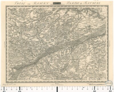
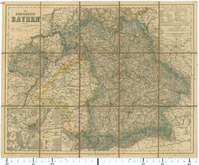
Atlas von Bayern : Geographisch-statistisch-historisches Handbuch zur Kenntniß des Zustandes von Bayern in seiner gegenwärtigen Beschaffenheit für alle Stände ; mit neun Charten
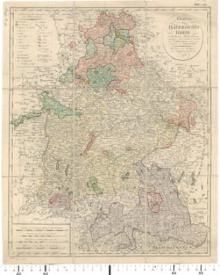
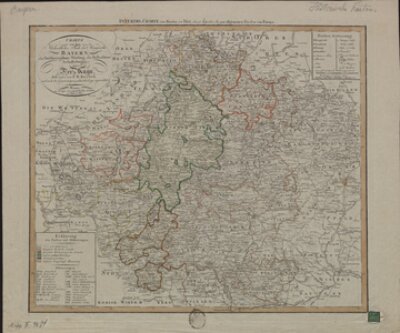
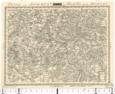
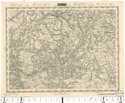
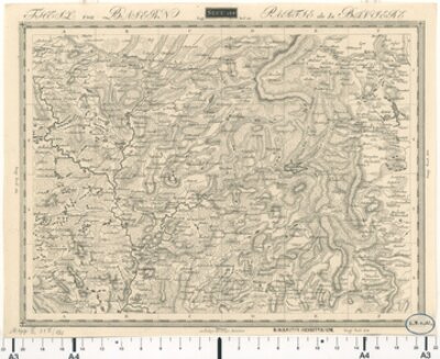
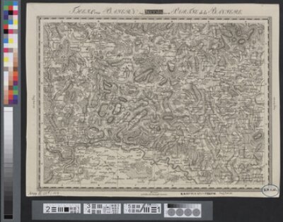
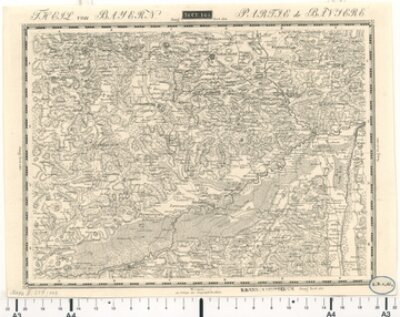
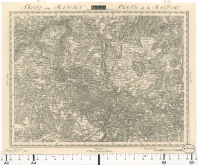
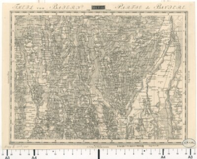
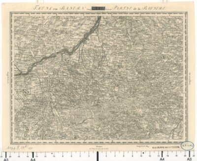
  • Retzat-Kreis Untermain-KreisObermain-Kreis Regen-Kreis Unterdonau-Kreis Oberdonau-Kreis Isar-Kreis Rhein-Kreis Allgemeine Geographie
  • Bayerische Staatsbibliothek
  • Identifikator: urn:nbn:de:bvb:12-bsb10807488-8
  • Identifikator: BV001557179
  • Signatur: Hbks/X 4 o
  • Beyer, Leonhard
  • Stein, Johann Adam
  • Hohn, Karl Friedrich
  • Stein [Verlag]
  • 1836
  • Nürnberg
  • NoC-NC

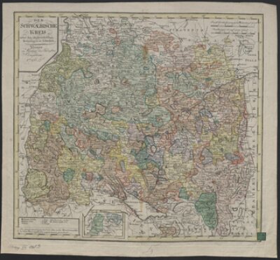
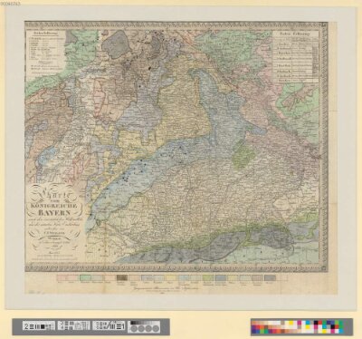
[...] Bodenſee und das Herzogthum Salzburg d im Norden die Gebiete des Kurfürſtenthums Heſſen des Großherzogthums Weimar der Herzogthümer Sachſen Hild burghauſen Saalfeld und Koburg Gotha des Königreichs Sachſen und der fürſtlich [...]

[...] Anzeigers und der Nationalzeitung der Deutſchen im J 1830 Folgendes Der verſtorbene Großherzog von Sachſen Weimar Carl Augu ſt machte mich einſt auf die merkwürdigen Torfmoore auf der hohen Rhön zwiſchen [...]

[...] ergab ſich im Schwedenkriege im I 1633 auf gedrohte Plünderung an den Herzog Bernard von Weimar ward während des ſpaniſchen Succeſſionskrieges im J 1703 von den kaiſerlichen zwei Mal eingenommen [...]

[...] und eingenommen und im Jahre 1634 von den Schweden auf Befehl des Herzogs Bernhard von Weimar geſprengt Nach der Säculariſation der geiſtlichen Stif ter im J 1803 kam Donauſtauf mit [...]

[...] 29 und 50 41 nördlicher Breite egen Norden begränzt ihn Kurheſſen das Großherzogthum Sººfen Weimar und die Herzog Sächſ Länder gegen Oſten dieſelben der Obermain und Rezat Kreis gegen Süden [...]

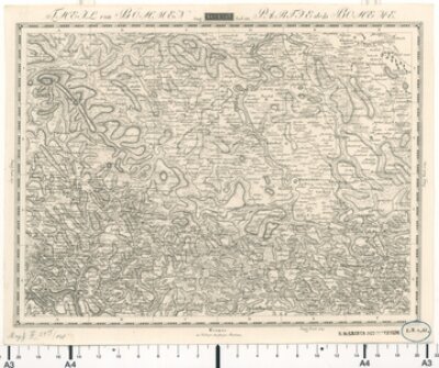
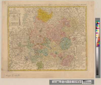
Reise Atlas von Bajern oder Geographisch-geometrische Darstellung aller bajrischen Haupt- und Landstraßen mit den daranliegenden Ortschaften und Gegenden : nebst Kurzer Beschreibungen alles dessen, was auf und an einer jeden der gezeichneten Straßen für den Reisenden merkwürdig seyn kann. [Gewidmet] Joseph August Grafen von Toerring / 0
  • Bayerische Staatsbibliothek
  • Identifikator: BV005573948
  • Identifikator: urn:nbn:de:bvb:12-bsb10804315-5
  • Signatur: Hbks/F 18 kcd
  • Riedl, Adrian von
  • Lentner, Joseph
  • Joseph Lentner [Verlag]
  • 1796 [erschienen 1796 - 1805]
  • München
  • NoC-NC

[...] 1633 wurde Regensburg das die Baiern beſetzt hatten von den Schwediſchen Generale Bernard Herzog von Weimar ſieben Tage lang belagert ſie ergab ſich mittelſt Vergleiches und zahlte Ioo ooo Thaler Brandſchatzung [...]

[...] den Kaiſerl und Baiern belagert wurde 17 würde hat es der Schwediſche General von Sachſen Weimar theils abgeriſſen theils abgebrannt Die Engelländer und Oeſterreicher eroberten es im Jahre 1704 mit [...]

[...] folgenden Jahre 1633 ergab ſich die Stadt an den Schwediſchen General dem Herzog von Sachſen Weimar der von Ulm nach Regensburg zog Im Jahre 1648 überfielen und plünderten die Schweden die [...]